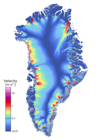
Ice Velocity

Ice velocity and its spatial derivative strain rate (which is a measure of the ice deformation rate) are key variables for estimating e.g. ice discharge and mass balance and are essential input for glacier models that try to quantify ice dynamical processes. Changes in velocity and velocity gradients can point at changing boundary conditions. Remote sensing techniques that utilize SAR and optical satellite data are the only feasible manner to derive accurate surface velocities of the remote Greenland glaciers on a regular basis.
The ice velocity (IV) products generated in the Greenland Ice Sheet CCI are derived from both optical and SAR data using combinations of different techniques. Details of the methods are provided in the Algorithm Theoretical Basis Document (ATBD).
Ice velocity is provided as gridded velocity fields (maps) in NetCDF format with separate files for x and y velocity components (in m/yr). The velocity represents a mean velocity value over a time period ranging from the time span of the satellite repeat-cycle (between 1 to 46 days) to a full season or year for the ice sheet wide velocity maps.
Click here to browse and download Ice Velocity products
Products by ENVEO are also available directly from http://cryoportal.enveo.at/.

![Science [&] Technology](/sites/default/files/documents/admin/Partner Logos/st_logo.jpg)


